
The Analogy
If you can order lunch, you can task a satellite
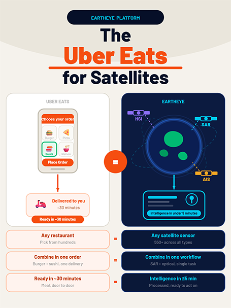
Eartheye works exactly like Uber Eats — except instead of restaurants, you’re ordering from a constellation of 550+ satellites. Instead of food, you receive ready-to-act intelligence on anything happening on Earth.

Uber Eats
The Network
Restaurants across the city
What You Order
Dishes from multiple restaurants in one order
What You Receive
A meal, ready to eat
How Fast
30–45 minutes to your door
How You Pay
Pay per order, no commitment
To Start
Download the app, order immediately

Eartheye Platform
The Network
550+ satellites orbiting Earth right now
What You Task
Multiple sensor types combined in a single workflow
What You Receive
Decision-ready intelligence — not raw data
How Fast
Automated extraction within minutes of data delivery
How You Pay
Deposit-based credit — like prepaid mobile
To Start
Register now, task with $0 deposit to begin
550+
Satellites on Platform
< 5 min
Intelligence Delivery
$0
To Get Started
10+
Sensor Types
9
Industries Served
Why It Matters
Satellite intelligence was never this accessible
Historically, accessing satellite data meant navigating lengthy procurement, coordinating with multiple providers, and waiting days for raw imagery that still needed expert processing. EARTHEYE eliminates all of that.
Built on Three Principles
How Eartheye removed every barrier
From the ground up, the platform was designed to solve three specific frictions that kept satellite intelligence out of reach for most organisations.
1
Accessibility
All sensor types — optical, SAR, hyperspectral, RF, AIS, and more — consolidated on a single platform. No more managing separate relationships with multiple satellite operators.
2
Usability
EARTHEYE extracts intelligence from tasked data in near real time and delivers ready-to-consume information — whether for national security, climate, or commercial decision-making.
3
Affordability
A prepaid deposit model — like prepaid mobile — means your deposit becomes your credit to task. Start with no deposit, or commit from $5,000 to unlock the full constellation.
How It Works
Three steps, from sign-up to insight
1
Register on the Platform
Sign up at tasking.eartheye.space. No upfront commitment required. Access the platform immediately with the Starter tier.
2
Task Your Satellites
Select the sensors you need — optical, SAR, hyperspectral, AIS, and more — and define your area of interest. Combine sensors in a single workflow.
3
Receive Intelligence
Within minutes of data delivery, EARTHEYE automatically extracts and delivers decision-ready information — Feeds, Indices, or raw data — to your preferred destination.
The Sensor Constellation
Every sensor type. One platform.
Like a restaurant menu with every cuisine available, EARTHEYE gives you access to every major satellite sensor type — task one, or combine several in a single order.
Multispectral — Day
Multispectral — Night
Hyperspectral
Synthetic Aperture Radar (SAR)
InSAR
Panchromatic (PAN)
Thermal Infrared
Full Motion Video
Greenhouse Gas (GHG)
AIS — Vessel Tracking
RF Communications
3D & LiDAR
What You Receive
Not just data. Intelligence.
EARTHEYE delivers three distinct output types — so you receive exactly the format your team needs to act.

Tasking as a Service — Data
Direct access to satellite tasking. Schedule any sensor to capture your area of interest in near real-time. Precise geospatial data with global coverage. Starting at USD 1.50 per sqkm.

Information as a Service — Feeds
Continuous streams of satellite imagery converted into structured, decision-ready insights. Instead of raw images, receive timely intelligence on what’s changing — oil spills, deforestation, vessel activity, and more. Starting at USD 100 per feed.

Indices — Analytical Layers
Mathematical models applied to satellite bands — including those invisible to the human eye — transformed into clear, actionable maps highlighting vegetation health, moisture, soil stress, land change, and more.
Real-World Applications
What organisations are ordering
EARTHEYE serves mission-critical operations across defence, government, and commercial sectors where timely situational awareness defines outcomes.
Pricing
Pay only for what you use
Like a prepaid mobile — your deposit becomes your credit to task satellites and access intelligence. Start with no deposit and scale up as your operations grow. There are no hidden fees. Every pound deposited is a pound available to task.
Two ways to onboard the EARTHEYE platform: without a deposit to explore limited functionality, or with a deposit from USD 5,000 to unlock the full constellation of 550+ satellites, advanced workflows, and information feeds.
Get Started
Your first satellite order
is minutes away
Register on the EARTHEYE platform today. No commitment required to begin. Scale as your intelligence needs grow.
Simple, Transparent Pricing
Pay Only for What You Use
Starter
For first-time or occasional users
Annual Deposit
No minimum
Pay Now via PayPal, Stripe, or debit Account
-
Imaging sensorsClick to view breakdown5
1 sub-m Multispectral Imaging (MSI)
1 above 1m MSI
1 sub-10m Hyperspectral Imaging (HSI)
2 sub-m Synthetic Aperture Radar (SAR) (X band)
Includes
- Single user, one tasking workflow
- Support via platform ‘contact us’
Standard
For regular users
Annual Deposit From
USD 5,000
Pay now, debit account
-
Imaging sensorsClick to view breakdown10
1 Panchromatic (PAN)
4 MSI (below 1m and above 1m)
3 SAR (X, C bands)
1 HSI
1 Thermal Infrared (TIR)
More of everything from users to sensors
- Multi-user, multi-tasking workflows
- Access to simple feeds
- Support via onboarding, platform ‘contact us’ and email
Enterprise
For related entities & organisations
Annual Deposit From
USD 100,000
Pay now, debit account, or pay later by invoice
Volume discounts available
Full Premium sensor suite, tailored to operational requirements.
Everything in Premium plus
- Hierarchical and multi-account management
- Data and information report generation
- Activity tracking
- Slack + dedicated support channel
- Support via onboarding, platform ‘contact us’, email, Slack and monthly check-in
* Contact Sales for automatic discounts on deposits over USD 100,000 for Enterprise plan.